Chincoteague and Assateague: What is the ground made of?
"For every 1-foot rise in sea level, it has been estimated that coastal barrier islands move 100 to 1,000 feet inland." 
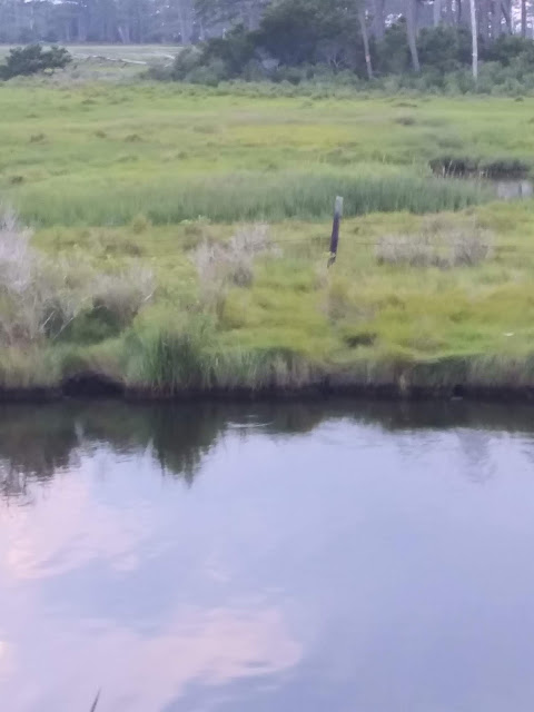
Perhaps one of the strangest things about Chincoteague is the land itself. This week I used the Web Soil Survey(WSS) to try and understand one of the craziest things we saw on our visit to Chincoteague. If you pay attention as you drive across the bridge to Chincoteague, you will see it too. And you will wonder as my son and I did. Why in the world would anyone build on an island where the strip of land is barely above the water level of the marsh.
 |
| Photo is taken from realestate.com This is one of many homes on Marsh Island |
That's right. There is a marsh island just off the shore of the island. And it is amazing that so many large residential building structures were ever allowed to be built there. And so, this week using the WSS, I will explore from what kind of soil this island is made?
 |
| Photo taken from pilotonline.com Image shows the new bridge to Chincoteague Island on the right and Marsh Island in the middle. |
 |
| Here is a view from Google Maps, circa November 2016, showing how close the water is to the residential housing on the thin piece of land. |
From the photo above you can see how tiny Marsh Island is. The only way off the island is the bridge extension that connects the island to the new bridge. In cases of flooding, residents will either have to evacuate by boat or use their vehicle prior to flooding and evacuate by using the bridge. This photo was taken in 2009. The bridge was set to open in January 2010. The 2010 U.S. Census reported 2,941 total residents in the town of Chincoteague. It estimates that in 2018 the population will be 2,879.
As Chincoteague Island is the last inhabited barrier island in Virginia, sea-level rise and erosion may drive residents to seek higher ground. This article from the Virginia Pilot,
Some Virginia barrier islands are shrinking by the day: "You can just feel it" really paints a grim look at the future of Virginia's Barrier Islands, but it is a fascinating time to watch the almost daily migration of sand that is changing the shape of the islands.
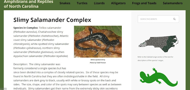
So let's take a look at the makeup of the soil. Here is where using that WSS is helpful. Thanks to the USDA and the Natural Resources Conservation Service, we can look at the types of soil on Chincoteague's Marsh Island and the main Chincoteague Island. This link will take you to the WSS and you will be able to navigate the site and explore information pertinent to general land use and planning. The site is not difficult to navigate and this being my first time using it. I can see the benefits it has for anyone planning to build a summer home or renting a vacation home. It helps to know the flooding possibilities and soil type before your journey. If I had studied this resource prior to my trip to the island, I would have packed more insect repellent. The soil saturation and composition is beyond prime for mosquito breeding.
Marsh Island Soil Map
https://www.nrcs.usda.gov/wps/portal/nrcs/detail/national/soils/?cid=nrcs142p2_053631
Soils of the Chincoteague silt loam series are nonacid Typic Sulfaquents (great group) that are very deep and very poorly drained. They are formed in loamy sediments and are found throughout the refuge impoundments and in salt marshes primarily between the barrier islands and the seaside mainland as well as some barrier tidal flats. Soil permeability is moderately slow and they are very poorly drained with slow runoff, and saturated with salt water. These soils provide habitat for wetland wildlife and spawning grounds for shellfish and fin-fish species. Common plant life consists of cordgrasses, glasswort, and saltgrass. Cultivated crops, nursery stock, pasture grasses and legumes, and loblolly pines are all unsuitable on this soil because of flooding by salt water, wetness, excess salt, and ponding. Construction is similarly unsuitable with additional limitations of low strength and potential groundwater pollution.
(page 3-4 of Chapter 3 of the FWS report https://www.fws.gov/uploadedFiles/CCP_Chapter3(1).pdf )
Chincoteague Island Soil Map Data
Chincoteague Island is a mystery. It is the last inhabited Virginia Barrier Island. It is not without its issues. There is a lot of salt in the soil and much of the land is prone to flooding. Nevertheless, there are nearly 3,000 people who live on the island and some 15,000 more who visit the island annually.
Let's just hope that the 2019 hurricane and storm season does not bring winds, rains, and oceanic storm surge that will cause more of the island to sink below sea level and disappear into the lagoon.
Comments
Post a Comment